May 13, 2010
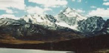
Cabeza de Condor
This is a beautiful mountain in the high desolate plains above La Paz. It means "Head of the Condor." From certain vantage points it looks like a giant bird with it's wings spread. It's something like 18,000 or 19,000 feet tall. It's very impressive.
Please leave a comment :)
July 26, 2009
Put a what on my head?

South Americans are known for being very superstitious, especially the people living high in the mountains. So what is the craziest superstition I've ever heard? It involves skinning a cat to get rid of a headache. You see, some of the campesinos believe that by wearing the skin of cat on their head they can get rid of a headache. A little strange? Definitely. It would be interesting to find out the logic behind that one, or at least the origin of the practice. What do cats know about headaches that we don't? Why not llama hair? They're more abundant than cats in the Andes.
July 10, 2009
Bolivias "American" Food
In addition to saltenas many street vendors in La Paz and El Alto sell something known as salchipapas. Rather than containing any kind of Bolivian type ingredients like chuno, guinea pig, or aji, salchipapas are made of french fries, hot dogs, mustard, and ketchup. This is considered by some to be "american food." The hot dogs are sliced up and mixed in with the french fries, and the whole thing is drizzled with mustard and ketchup. It tastes pretty good. You should try it.
July 5, 2009
Spicy Bolivian Chicken
I found this recipe online and tried it at my sisters house. Even her children liked it so we had it again when my parents came out to visit. This version comes from cdkitchen.com, but I'v modified it slightly.
1 1/2 lbs. skinless, boneless chicken breasts, cut in. 1/2 in strips
2 tbsp oil
1 lg. onion, chopped
2 red bell peppers, cut in 1/4 in. strips
2 cloves garlic, finely chopped
1 tsp crushed hot red pepper (or more for spicier)
3 C. chicken broth
3/4 C. peanut butter
10 oz. package peas, thawed
salt and pepper to taste
Season chicken with salt and pepper. Heat oil in lg. frying pan to medium, add chicken strips and saute, while stirring until chicken is white and starting to brown. Add onion, peppers, and garlic and cook until tender, then stir in hot pepper. Add broth and peanut butter, and simmer, stirring occasionally for 10 min. Stir in peas and cook 5-10 min. stirring occasionally until sauce is thick and mixture is heated through. Serve over rice or boiled potatoes.
July 1, 2009
Drive through My First Area
The music on the video is very strange. Just ignore it; mute it or something. Anyway, I found this video on youtube. It films my whole first area from the top at the edge of Satelite in El Alto all the way to the bottom of my area in La Paz. As you can see it is situated on a very steep hillside. My area went from 12,000ft elevation at the bottom up to a height of 14,000ft at the top.
June 27, 2009
La Comida

Pacenos eat a wide variety of foods, but most often they eat simple meals of rice and potatoes. One favorite dish is something called chuño (it is pronounced choon-yo). Hundreds of years ago the incas and other indigenous andeans survived on chuño. Its a little bit like a freeze dried potato. The potatoes are set out in the sun during the day and then buried in the ground and frozen at night. This is repeated several times and the result is a blackened potato that can be stored for over 100 years. Most outsiders don't like chuño at all. Definitely an acquired taste.
February 8, 2009
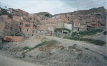
Life in La Paz

The city is built in a deep depression of the high flatlands known as the Altiplano. Much of the city is built on the steep slopes which have been subject to large landslides over the years. The homes in this picture are in the neighborhood of Las Lomas in La Paz. They are typical of the hundreds of thousands of Pacenos living in poverty. The richer live in homes more centrally located, and not on the steep hill sides.
January 19, 2009
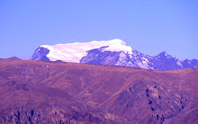
Huayna Potosi

This 20,000 foot mountain can be seen from almost anywhere in La Paz. It sits just outside the city of El Alto (elev. around 14,000 feet). Some of El Alto is seen in this picture. Anyway, the mountain is a popular climb among Europeans because you don't need to pay large amounts of money to climb in Bolivia like you do in the Himalayas. Also, this mountain can be climbed in just 2 or 3 days. However, these mountains aren't as well known to North American climbers.
January 10, 2009
Color of Cats
"Color of Cats" is the Aymara translation for Lake Titicaca. It is the largest lake in South America by water volume, and the highest navigable lake on earth at 12,500 feet above sea level! Just a few hours bus ride from La Paz it is a popular tourist destination. This picture was taken by Taylor Bullock, one of my mission companions.

Copacabana is a small town located on the Bolivian side of the lake (the lake is shared with Peru to the northwest). On the top of this hill which overlooks both the town and the lake there is a shrine to the Virgin Mary. 95% of Bolivians are Catholic. Annually, thousands of pilgrims make the trek to this site to worship.

The wind off the lake can get quite strong due to its extreme altitude and its location between the massive peaks of the Andes.

December 20, 2008
El Condor Pasa

The song on this blog is performed by Simon and Garfunkle, but it was written in 1913 by an Andes native. All Bolivian music has the same sound to it as this song. I chose to use it on here because of that. Every time I hear it I think of Bolivia
December 19, 2008
Bolivian Home

This is a typical home in La Paz. The door leads into a small front yard or courtyard, and the house is behind. The walls generally have shards of glass from broken bottles embedded at the top to serve as a kind of deterent to intruders. The houses are all built with either brick or adobe and typically have a concrete floor. This particular family had only packed dirt for their floor. Poverty is a huge problem.
December 4, 2008
High on a Mountain Pass
 On Christmas day 10 years ago I went up to the high mountain pass that heads up out of La Paz, cuts through the Andes, and heads down to the jungle. We hiked up a ways from the road and found this wild horse. Probably not the smartest thing to take a picture next to. I estimated we were at about 16,ooo feet elevation. The highest point I've ever been. Christmas time is in the summer in South America and I would guess temperatures were in the 40's on that day.
 This is a picture of a typical street in the city of El Alto, located in the high plains above La Paz. It is a very desolate and melancholy town. Most people there commute down to La Paz to work. The mountain in the distance is 20,000 foot Huayna Potosi.
 November 27, 2008
Gateway of the Sun
 This image is engraved on the "Gateway of the Sun" at Tiahaunaku; ancient temple ruins not far from La Paz. One interpretation makes the tie between this culture and the ancient Israelites in Jerusalem. As the interpretation goes; the figure in the carving is holding the stick of Judah in his right hand and the stick of Joseph, consisting of Ephraim and Manasseh in his left hand as described in the book of Ezekiel 37:16. As documented in the Book of Mormon, a family from the tribe of Joseph fled Jerusalem at the commencement of the reign of King Zedekiah in about 600B.C. By this interpretation the Bible would be the stick of Judah containing the records of those in ancient Jerusalem and the the Book of Mormon represents the stick of Joseph containing the records of those in the ancient Americas. Not surprisingly therefore, the temple ruins at Tiahuanaku have a striking resemblance to that of the Temple of Solomon described in the Holy Bible.
November 22, 2008
The Roof of South America

At the dizzying height of two and a half miles above sea level; La Paz appears to float among the clouds surrounded by the towering peaks of the Andes.
Just How High Is It?
In the U.S. Denver is famous for being the "mile high" city. If La Paz were superimposed on Denver; it would be buried 8,000 feet below the city streets of La Paz!

That means La Paz could sit near the top of one of the tallest mountains in the U.S. The top of 14,411 foot tall Mt. Rainier in Washington State is at about the same elevation as La Paz's airport in El Alto!
 Mt. Rainier as seen from Commencement Bay in Tacoma, WA.

This is me walking with some strays on a street in the city. This was my first area on my mission.
Subscribe to:
Posts (Atom)